When buyers start looking at Marin County real estate, the local climate is often just as important as the floor plans. The weather and climate in Sausalito CA offer a distinct advantage over the cooler, fog-heavy neighborhoods directly across the bay in San Francisco. Understanding how these coastal weather patterns work is essential for choosing the right property and preparing for daily life here.
As we move through 2026, buyers are paying closer attention to environmental factors like winter rainfall and daily sun exposure. The local geography creates unique temperature pockets that can drastically change your daily experience depending on where your house sits on the hill. Evaluating these climate details early in your search will help you find a home that aligns with your lifestyle and comfort preferences.
The Mediterranean Climate of Sausalito, CA
Sausalito enjoys a classic Mediterranean climate defined by moderate temperatures and distinct seasonal shifts. This means residents experience long, dry summers and shorter, wet winters without the extreme temperature swings found further inland. The consistent weather allows for year-round enjoyment of outdoor amenities like the Marin Headlands and waterfront parks.
Daytime temperatures remain remarkably stable throughout the calendar year. January is typically the coolest month, bringing average daytime highs around 57 degrees. By late summer, the area warms up significantly, with September usually serving as the warmest month and seeing average highs near 70 degrees.
This mild baseline is a major selling point for those relocating from regions with harsh winters or sweltering summers. You rarely need robust air conditioning, and heavy winter heating systems are largely unnecessary. Instead, homes here rely on good insulation and natural ventilation to stay comfortable year-round.
Average Monthly Temperatures and Precipitation
The transition between the wet and dry seasons dictates the rhythm of the local environment. Sausalito receives approximately 24 inches of rainfall annually, with the vast majority falling during the winter months. Sunshine peaks in May, offering nearly 11 hours of daylight per day for outdoor activities.
Understanding the rainfall distribution helps buyers know what to expect when touring properties during different seasons. The precipitation data reveals a stark contrast between the winter and summer months:
-
The rainy season runs from December through March, bringing the bulk of the annual moisture.
-
December stands as the wettest month, averaging 5.4 inches of rain across roughly 13 rainy days.
-
The dry season stretches from May to October, characterized by clear skies and minimal precipitation.
-
July is historically the driest month, averaging just 0.01 inches of measurable rain.
Sausalito Microclimates and the Marine Layer
The defining feature of Bay Area weather is the marine layer, and Sausalito interacts with this phenomenon in a very specific way. During the summer months, warm inland air rises and pulls cold, moist air off the Pacific Ocean through the Golden Gate strait. This clash of temperatures creates the famous coastal fog that blankets the region.
Fortunately, the towering topography of the Marin Headlands acts as a natural buffer for the city. These hills block the thickest, heaviest bands of fog from settling directly over the downtown area. As a result, residents here enjoy significantly more clear skies and sunshine compared to neighborhoods located in San Francisco proper.
The daily fog cycle is highly predictable during the summer season. The marine layer typically rolls in during the late afternoon, dropping temperatures and bringing average wind speeds of 10 to 14 mph. By late morning the following day, the sun usually burns off the fog, revealing bright blue skies for the afternoon.
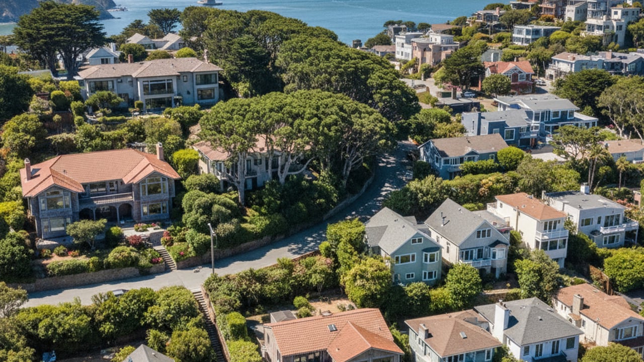
How Local Microclimates Affect Different Property Types
Elevation plays a massive role in how much sun and fog a specific home receives on any given day. Waterfront homes situated near the marina sit at sea level, placing them closer to the marine layer and exposing them to cooler afternoon breezes. These properties offer incredible access to the water but generally experience lower daily temperatures.
Conversely, homes located higher up in the hills often sit in what locals call the "banana belt" - an elevation band that rests above the low fog line. Properties in this zone receive substantially more direct sunlight and warmer ambient temperatures. Buyers looking at hillside homes - which frequently list above $2,000,000 - should carefully weigh these microclimates during their search, as moving just a few streets up the hill can completely change a property's daily weather profile.
Commuting in Sausalito: Ferry, Golden Gate Bridge, and Highway 101
Seasonal weather patterns directly influence the daily commute for residents traveling into San Francisco or further into Marin County. The Sausalito Ferry is a highly popular transit option, operating daily across the bay. However, heavy summer fog, high wind events, or severe winter storms can occasionally cause schedule delays or require reduced speeds for safety.
For those driving into the city, the marine layer frequently impacts visibility on the Golden Gate Bridge during morning and evening drives. Drivers must remain cautious during the summer months when the fog is thickest at the bridge's elevation. The bridge acts as a funnel for the coastal winds, making the crossing noticeably gustier than the surrounding surface streets.
Winter weather brings a different set of commuting challenges to the region. Significant winter rainfall often slows traffic along the Highway 101 corridor, especially during the peak rainy season between December and February. Commuters should build flexibility into their schedules during these wet months, as steady rain consistently increases drive times throughout the Bay Area.
Frequently Asked Questions
What is the weather like in Sausalito?
Sausalito features a mild Mediterranean climate with dry, sunny summers and wet, moderate winters. Average daytime highs range from 57 degrees in January to about 70 degrees in September. The city experiences less fog than San Francisco due to the protective barrier of the Marin Headlands.
What is the best time of year to visit Sausalito?
September and October are widely considered the best months to visit the area. During this late summer window, the coastal fog patterns subside, and average high temperatures hover comfortably around 70 degrees. May is also an excellent option, offering nearly 11 hours of daily sunshine before the heavy summer marine layer establishes itself.
What's the crime rate in Sausalito, California?
Sausalito generally reports lower crime rates compared to broader state averages, with property crime making up the majority of reported incidents. According to recent municipal data, violent crime rates remain well below national benchmarks. Buyers reviewing the area often consult local police department statistics for exact neighborhood figures.
Do people like living in Sausalito?
Residents highly value the city for its stunning waterfront views, walkable downtown, and mild coastal climate. The combination of easy access to San Francisco and immediate proximity to the Marin Headlands makes it highly desirable. The ability to enjoy outdoor recreation year-round without extreme weather is a major draw for the local population.